Take a Drive: Stunning Scenic Byways
Staunton is not only a portal to Skyline Drive, the iconic 105-mile thoroughfare bisecting Virginia’s Shenandoah National Park, but it also sits at the northern cusp of the Blue Ridge Parkway. Check out these two scenic drives, arguably some of the best thoroughfares on the east coast for leaf-peeping:
skyline drive
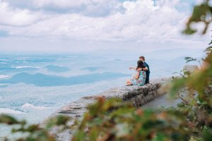
Flanked by the 200,000 acres of the Shenandoah National Park, Skyline Drive is laden with 69 different scenic overlooks along the 105-mile long public road. For ambitious leaf-peepers, allow 3 to 4 hours to drive the entire Skyline Drive which doesn’t include stops. Hop on the scenic byway via the Rockfish Gap entrance just 20 minutes from Staunton. Popular overlooks closest to the Southern entrance are Big Run Overlook (milepost 81.2) and Crimora Lake Overlook (milepost 92.6). The valley of Big Run is one of the park’s most scenic and opens into the depths of the park’s largest stream. Crimora Lake Overlook sits at 2,985 feet where you can see the strewn rock slopes of Rocks Mountain.
Try a leg-stretcher and see the fall colors up-close. From Skyline Drive try Blackrock Summit (milepost 4.8), a geological wonder that’s an easy 1-mile loop. Although not the highest peak in the South District, this is probably the easiest to get to with rewarding views. From the summit of boulder-strewn Blackrock enjoy views that extend for miles in multiple directions. Another short and sweet hike is the Frazier Discovery Trail (milepost 79.5). This area used to be the Frazier’s farm and you can still see evidence of their past in the apple trees that still dot the mountain.
blue ridge parkway
In Rockfish Gap, 20 miles from Staunton, Skyline Drive also merges into the southbound Blue Ridge Parkway, the iconic byway running 469-miles from the Shenandoah National Park to the Great Smoky Mountains National Park in Tennessee. While there are a staggering 280 viewpoints, some of the most spectacular sites along the entire parkway are in the northernmost section—just minutes from Staunton. First, the Humpback Rocks Recreation Area offers access to a range of hiking trails, with options for quick leg-stretchers or extensive loops. The massive 3,080-foot rock formation known as Humpback Rocks is also touted as one of the parkway’s premier vistas—and one of the most popular.
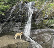
Just after Humpback Rocks is another treasure: The Sherando Lake Recreation Area is one of the byway’s most inviting detours. The 25-acre, spring-fed lake is edged by hiking trails, leafy campsites, and a sandy swimming beach. Slightly further south, the parkway also offers access to the one of the most stunning waterfalls in the east—and the highest in the Virginia Blue Ridge—Crabtree Falls. Two trailheads just a few miles from the parkway offer hikers intimate access to the cascades plunging 1,800-foot course to the Tye River.
Newsletter Sign-up
Stay up to date on the latest and greatest happening in Staunton.